Atlanta city leaders, transportation officials, and other dignitaries gathered on Halloween for a ceremonial groundbreaking to kick off the South Boulevard Complete Streets project that some advocates have wanted for nearly a decade. But what does that mean, exactly?
We’ve followed up this week with Atlanta Department of Transportation leaders for the official word on how 2.4 miles of Boulevard—an important north-south corridor for the city’s entire eastside—will be changing over the next 10 months. And to learn how most of it—but not all—will become a protected new route for bicyclists and micromobility users. [UPDATE: 1 a.m., Nov. 7: Grant Park Neighborhood Association officials send word that images provided here by ATLDOT are dated, in that the final design, which broke ground last week, removes all on-street parking along the entire 2.4-mile corridor. Please see comments below for instructions on how to view full plans.]
In a nutshell, according to ATLDOT spokesperson Michael Frierson, bike lanes protected with bollards will be installed from about a block south of Interstate 20, down to McDonough Boulevard. The latter point is where Boulevard ends, just outside Atlanta’s federal penitentiary.
By our count, that’s a little more than two miles.
 An example of how Boulevard will be sectioned for new uses along Grant Park near Zoo Atlanta. Courtesy of ATLDOT
Sections of bike lanes along that part of Boulevard will also be designated with green paint as another safety measure.
Beyond that, Frierson supplied the most recent and thorough linear overview of the South Boulevard Complete Streets project, showing each segment in sequential panels.
Starting at the south end, it extends from McDonough Boulevard (near the prison) to Woodward Avenue (a block south of Oakland Cemetery), as seen here:
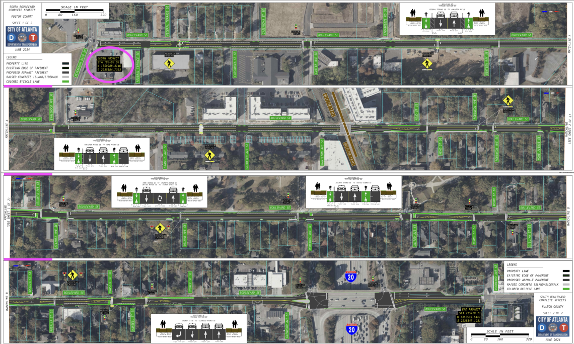 These four linear panels—starting at top left, from the south near Atlanta's federal prison—illustrate how the South Boulevard Complete Streets project will alter 2.4 miles of Boulevard soon. Courtesy of ATLDOT; alterations, Urbanize Atlanta
The panels illustrate all 2.4 miles of travel-lane reconfigurations, pavement striping, cycling infrastructure, and pedestrian crossings with flashers, per Frierson. (For a closer view, zoom in on this South Boulevard Concept Layout.)
But there’s one important note, according to Rebecca Serna, executive director of safe streets advocacy organization Propel ATL.
The concept layout is the best resource the city has, says Serna, but it was created before final plans were approved. “We advocated for the bike-lane protection to be prioritized over a handful of free on-street parking spaces at the Beltline crossing near Mellow Mushroom—these would have been used primarily by food delivery drivers, not residents—and this change is not reflected in the concept,” Serna noted via email.
Construction on the Boulevard Complete Streets initiative is scheduled to officially start this month and wrap in September next year, according to ATLDOT.
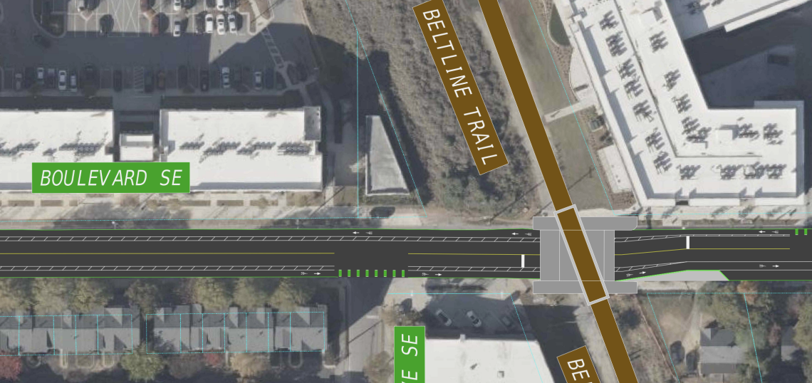
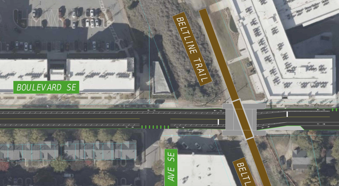 Plans for how the Boulevard bike lanes will meet the Beltline's under-construction Southside Trail and travel south (or left). The section at right will also see continuous, protected bike lanes not interrupted by parking spaces, per Propel ATL. Courtesy of ATLDOT
Along with the Beltline, other points of interest along the route include Zoo Atlanta, Grant Park (the city’s oldest greenspace), Boulevard Crossing Park, Red’s Beer Garden, El Progresso #14 (aka, Prison Tacos), and numerous other businesses.
The changes are also designed to help make Boulevard safer for Grant Park visitors on foot and kids walking to area schools, as Serna wrote in a recent retrospective.
Localized efforts to change Boulevard began to bear fruit in 2017, back when neighbors succeeded in convincing city officials to extend the Monroe Drive/Boulevard Complete Street project farther south. City leaders officially proposed the South Boulevard Complete Streets in 2021, and years of community engagement, meetings, and an open house followed, leading up to Friday’s groundbreaking.
...
Follow us on social media:
Twitter / Facebook/and now: Instagram
• Grant Park news, discussion (Urbanize Atlanta)