Accompanying the bombshell news this week that downtown Atlanta’s Stitch project had landed enough federal cash to fund construction of its first phase was another surprise: An elongated, multi-use Atlanta BeltLine branch called the “Flint River Trail” project not only exists, but it, too, has been awarded a substantial bag of federal grant funding.
Which begs the question: What’s this Flint River Trail the feds speak of, and how exactly will it relate to the BeltLine?
The Flint River Trail, it turns out, is a broad term referring to the Atlanta Regional Commission’s 2023 application for federal infrastructure funding, which mentioned a “BeltLine to Flint River Trail” as a means of connecting intown to the southside natural water resource.
For more than a decade, community groups such as Finding the Flint and Aerotropolis Atlanta Alliance have been putting plans together to unearth and showcase the river’s headwaters through a visioning process. As Georgia’s second longest river, the Flint begins near the Atlanta airport, where it’s either obscured by culverts, hidden beneath runways, or fenced-off on airport property, before flowing more than 340 miles and joining the Chattahoochee River at the Florida line.
 Plans compiled in 2021 for a trail section near a 23-acre industrial property called the Tift site. Willingham Corridor Improvement Study, via ARC
Eventually, the ARC’s vision calls for creating a new, contiguous multi-use trail that would branch off the BeltLine near today’s Lee + White district in West End and trickle down to Lovejoy, a distance of 31.5 miles.
But there’s a long way, so to speak, between here and there.
According to ARC spokesperson Paul Donsky, the $50-million federal grant announced this week—part of a bipartisan infrastructure bill approved by Congress in 2021—will pay for the construction of the purple segments outlined in the graphic below. [CORRECTION: 11:12 a.m., March 15: The $50-million grant will also cover the cost of preliminary engineering and other planning work for the green segments below, but not construction of those trails.]
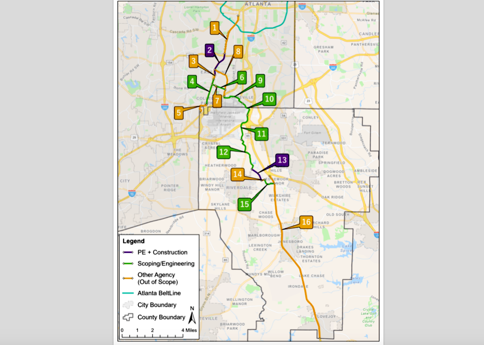 Courtesy of Atlanta Regional Commission
The purple sections—two and 13—are considered more shovel ready, in that planning by the City of East Point and Clayton County has already been set in motion. Green sections will require more upfront visioning and planning before construction can begin, according to Donsky.
In Clayton County, the one-mile trail section will connect Drew High School with Southern Regional Medical Center.
The longer trail segment, covering 1.6 miles in East Point, will run along U.S. 29 (Main Street) from the city’s historic downtown up to the Lakewood MARTA station, just north of Langford Parkway. The broader goal, according to the ARC, is to reconnect the Colonial Hills neighborhood, which was bisected by Langford Parkway’s construction in the 1960s.
The trail route is designed to link together several key attractions—the Ballethnic Dance Company, the East Point Farmers’ Market, East Point Public Library, and City Hall—before it ends at West Cleveland Avenue. That’s at the northern end of the downtown district, four blocks from the East Point MARTA station. (It’s worth noting the City of East Point is building another four-block trail segment that will pass in front of the East Point MARTA station, helping fill the gap.)
But if strolling or pedaling along these trails sounds nice, don’t hold your breath.
Donsky says construction of segments two and 13 isn’t expected to kick off until 2030, as no engineering work has been completed, and both will “have to go through a lengthy process that includes environmental review, right-of-way acquisition, [Georgia Department of Transportation] permitting, and approval.”
At this point, the schedule calls for completing trail construction in 2032.
But there’s good news for ATL trail enthusiasts regarding segment one: The 2.6-mile trail section extending southward off the BeltLine along Lee Street could happen sooner.
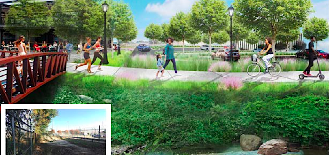
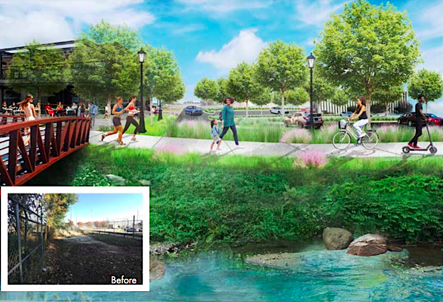
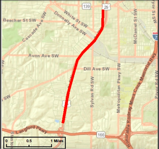 Plans for the 2.6-mile trail segment in Southwest Atlanta. Courtesy of ARC
That segment will run between West End and the Lakewood MARTA station. It’ll be raised and made of concrete where space permits, incorporating a landscaped buffer to protect pedestrians, cyclists, and wheelchair users from vehicle lanes. The bulk of the $8.1-million project is being funded through ARC’s Livable Centers Initiative, with 20 percent of those costs sourced from a City of Atlanta match, according to Donsky.
The Atlanta Department of Transportation’s website forecasts segment one construction starting in 2027 and wrapping up two years later.
A project description indicates the trail will run along the east side of Lee Street, which will be reconfigured from five to four lanes. Wayfinding would be provided throughout, as would intersection improvements at each street crossing. Plus, a new HAWK (or High-Intensity Activated Crosswalk) signal would be installed to connect Westside Trail BeltLine users to the new trail between Donnelly and White streets.
This story has been modified from an earlier version to clarify what this week's $50-million federal grant will pay for.
...
Follow us on social media:
Twitter / Facebook/and now: Instagram
• East Point news, discussion (Urbanize Atlanta)