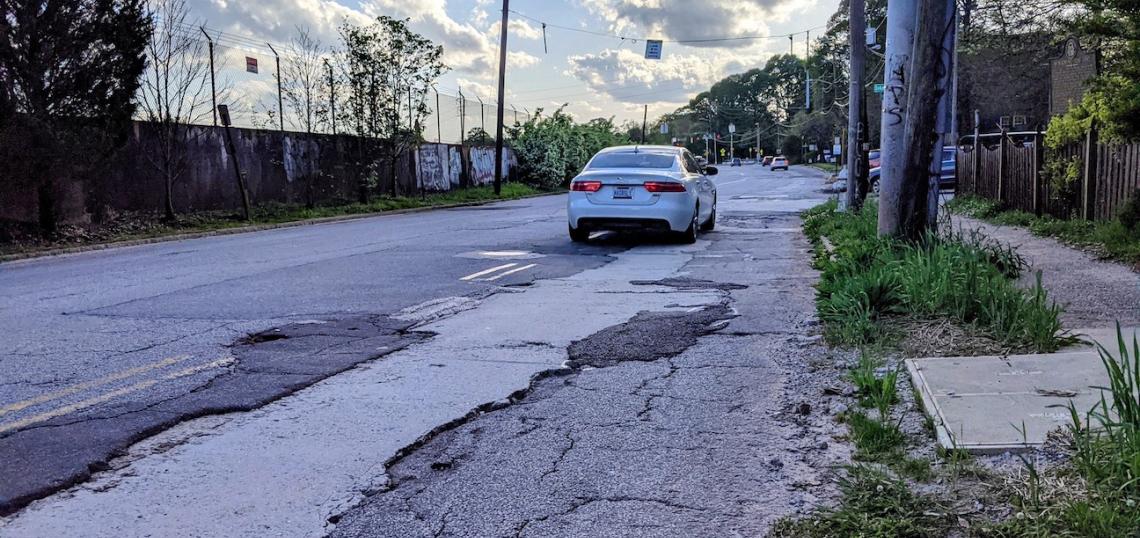
When asked recently to consider the present state and possible future of DeKalb Avenue, a major east-west Atlanta corridor that’s been likened to a drag strip in a warzone, Rebecca Serna noticed something surprising.
Serna, the Atlanta Bicycle Coalition’s executive director, has been advocating for changes to a street her organization considers dangerous since publishing a “Fix DeKalb Ave” petition in 2014.
But apart from some recent sidewalk repairs, the corridor remains in largely the same condition as seven years ago.
“I saw several people running on the corridor, which didn't happen much before those [sidewalk] repairs started,” Serna optimistically noted one day in March. “Yes, we continue to follow this project closely.”
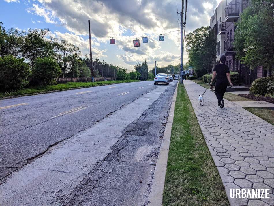 Pedestrians on DeKalb Avenue are separated by a couple of feet from speeding vehicles contending with quagmires of potholes. Josh Green/Urbanize Atlanta
Advocates for safer roadways—or “complete streets,” in which vehicles share space with bicycle lanes and wider sidewalks—have gone so far as to organize “slow roll” protests on DeKalb Avenue in recent years, with dozens of cyclists slowing traffic during rush hours. The pothole-riddled corridor, they contend, is a horror show of dangerous conditions and ill-conceived transportation planning: zero bike lanes, a dearth of turn lanes at key intersections that consistently clogs traffic, and an outdated reversible center lane—aka, the “suicide lane”—that statistics show increases car collisions.
So what’s the holdup—and is there hope for fixes soon?
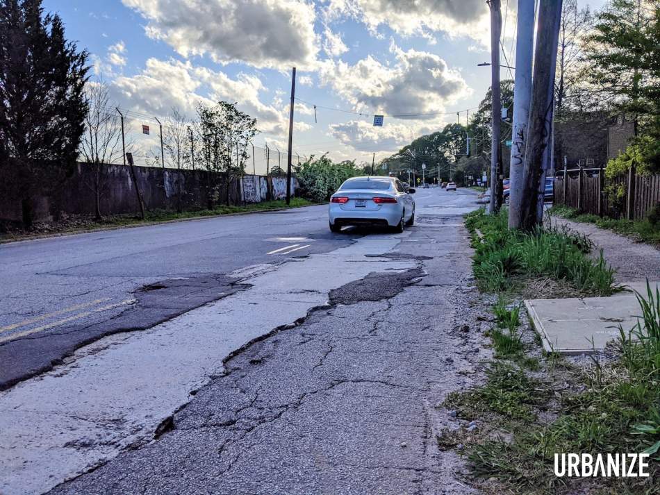 Following infrastructure work last year, the roadway's condition has been a tooth-jarring experience for drivers and cyclists. Josh Green/Urbanize Atlanta
As with complete street projects on Cascade Avenue and Campbellton Road, DeKalb Avenue’s transformation was supposed to be covered by the $250 million in Renew Atlanta TSPLOST funding voters overwhelmingly approved in 2015. But the cost of projects on that list, it turns out, vastly exceeded funding for infrastructure improvements, and a “re-baselining” to shuffle priorities ensued—with DeKalb Avenue’s full overhaul missing the cut. Serna calls that whole episode “frustrating.”
Our inquiries with the Atlanta Department of Transportation and other city officials regarding DeKalb Avenue’s repair schedule and scope haven’t been returned.
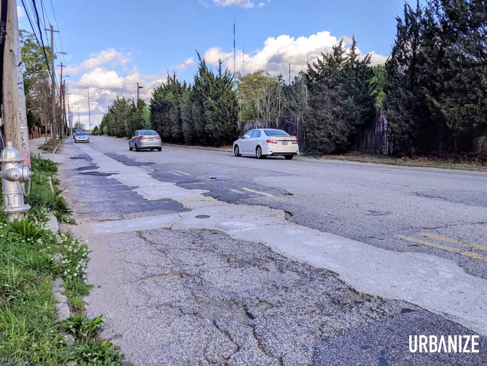 The "suicide lane" in action, eastbound, one evening this week. Josh Green/Urbanize Atlanta
But Renew Atlanta’s website shows that upgrades originally expected to start five years ago—road resurfacing from downtown to city limits near Decatur, removal of the reversible lane, protected bike lanes in places, traffic signal coordination, and intersection improvements—could be underway as soon as August.
The target finishing date is August 2022, and we’re told the bidding process for DeKalb Avenue work was recently ongoing. But the broader project has already been delayed at least twice in the past year.
The work would cover a corridor spanning roughly four and 1/2 miles, dotted with six MARTA stations and routinely ignored speed limit signs of 30 mph. The budget to rework it, as last posted by the city, is around $4.5 million.
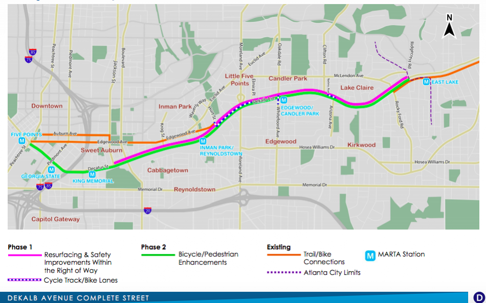 The complete street project plan. City of Atlanta; Renew Atlanta/2020
Recent statistics speak to the need for change. Between 2015 and last year, nearly 1,000 vehicle crashes had occurred on the stretch of DeKalb between downtown and the city limits at East Lake MARTA Station. That stretch was used by up to 20,000 vehicles per day in 2019, per city estimates.
Serna, who’s studied the plans, helped paint the picture of what Atlantans might expect, starting in the east. Biking or riding scooters along the corridor as a whole, she says, “will likely be safer because traffic should move more slowly and predictably.”
The planned improvements will span eastward basically from the MARTA King-Memorial Station to a few blocks shy of the Decatur line.
“Originally, the project stopped at Rocky Ford [Road], but we were able to get it extended to the city limits at Ridgecrest [Road],” Serna notes. “There are a few blocks of unincorporated DeKalb County roadway that we would like DeKalb to restripe to match the rest of the corridor after Atlanta finishes its section.”
The existing PATH Trail along DeKalb Avenue near the East Lake MARTA Station will see a buffer space created when traffic lanes are reconfigured from four lanes to three. Serna expects that to enhance safety and comfort similar to the “planter lane” nearby in Decatur. (Decaturites lampoon the planters for their ragtag aesthetics, but they've worked in keeping speeding cars away from people.)
At Rocky Ford Road, where the PATH Trail currently ends, the DeKalb Avenue project should make it easier to take McLendon Avenue through Candler Park or continue heading west on DeKalb. “I believe there will be either a bike lane or a buffered space that ends at the private pool on DeKalb,” notes Serna.
For anyone riding from Edgewood or Kirkwood toward Candler Park, a new short section of bike lanes from Arizona Avenue to Clifton Street could make the trip easier.
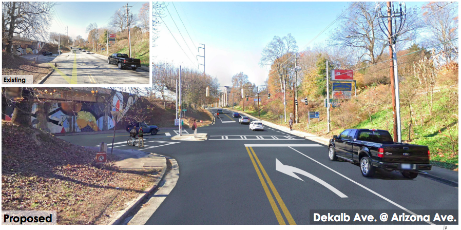 Proposed changes at Arizona Avenue include turn lanes and a short stretch of protected bike lanes to Clifton Street. City of Atlanta; Renew Atlanta/2020
“Bike commuters at CDC and Emory [University] advocated for this section,” says Serna, “which will make their daily route to work simpler and safer.”
Next, heading west, a protected cycletrack is expected to begin a few blocks west of the Inman Park-Reynoldstown MARTA Station, ushering people on two wheels over Moreland Avenue.
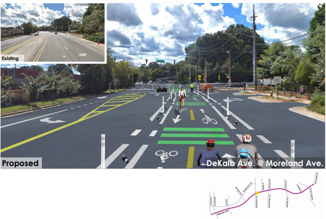 Proposed DeKalb Avenue changes at Moreland Avenue before plans were revised to move bike lanes adjacent to the curb, per the bicycle coalition. City of Atlanta; Renew Atlanta/2020
“We really pushed for that to connect to the MARTA station, as indicated in the Mayor's Action Plan for Safer Streets,” says Serna. “But the engineers decided the left turn bays were more essential than connecting people on bikes and scooters with transit.”
Farther west, turn lanes at Krog Street should make life easier for drivers.
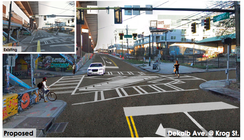 Turn lanes would be installed to allow for timed vehicle left turns at Krog Street. City of Atlanta; Renew Atlanta/2020
Then at the King Memorial MARTA Station, plans call for the cycletrack to end. “Most people on bikes,” Serna notes, “will hop over to Edgewood Avenue to use that bike lane if they're heading farther west.”
The remade DeKalb Avenue, as proposed, might not fit the nebulous definition of what a complete street is, but Serna says it will unquestionably be safer. The bicycle coalition, meanwhile, continues to hold out hope for the metamorphosis of DeKalb into a true greenway one day.
“If that project ever gets built as promised,” says Serna, “it would be the most complete street in Atlanta.”
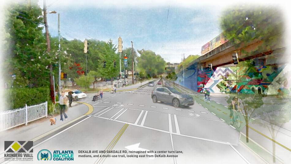 The bicycle coalition's idealized vision for DeKalb Avenue at Oakdale Road, where traffic frequently clogs when drivers turn and road conditions are hostile for bicyclists. Atlanta Bicycle Coalition; designs, Kronberg Urbanists + Architects
• Blocks of Midtown bike lanes debut; quickly mistaken by drivers for long parking spaces (Urbanize Atlanta)


